Category Archives: Place Based Policy

Geography 2050 – finally, a strategic dialog based on geography

2050 LogoIn the Fall, I was elected to the Council of the American Geographical Society, which is a cool organization with a very long history.  It was founded in 1851 as the first scholarly organization in America dedicated to the study of geography.  And, as you might expect from the era, they were heavily involved in mounting expeditions to the Poles, to the American West, and to exotic countries of which we (Americans) knew little.  Expedition was a primary mode of geographical research.

Well, the world has changed.  In the 20th century, we saw the rise of satellite remote sensing and the establishment of a global positioning system that enabled precision geopositioning by surveyors, and at the beginning of the 21st century, anyone with a cell phone.  Also, over this 160 years, the actual geography of the world has changed.  While the continents have only moved centimeters, humans, human activity and the technologies we have unleashed have remade the geography of the world.  And, this process of change will only accelerate in the future.

It is with this view on the world that the AGS has come to revive the role of expeditions.  Yes, the AGS will continue to mount socalled “Bowman Expeditions” named after their former Director Isaiah Bowman, to work with local and indigenous populations to make sense of their world through participatory mapping.  But in addition, AGS will now be exploring our future world as it convenes its Fall Symposium entitled Geography 2050:  Mounting an Expedition to the Future.

Screen Shot 2014-09-04 at 1.51.49 AM

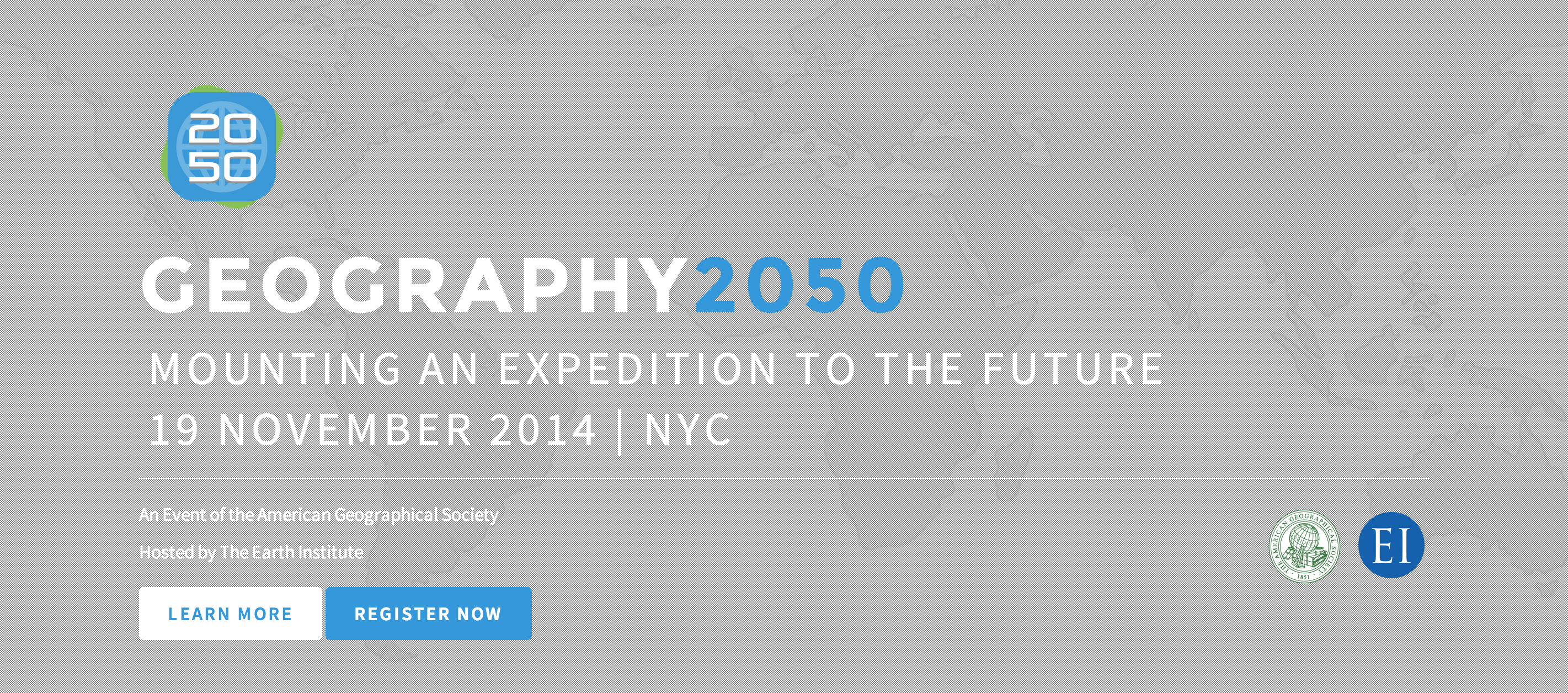
This effort is not just a single event.  The November 19th Symposium, hosted by Columbia University’s Earth Institute in the historic Low Library, will be the inaugural event of a multi-year strategic dialog about how our world will change between now and 2050, the major factors driving these trends, and the investments that we will need to make in order to better understand, anticipate, and weather this change.

The coolest thing is that this event is not just about sitting and listening  to smart people (though, feel free to come, sit and listen!).  Rather it is about engaging this process as a thinker yourself, and engaging Geography 2050 as a platform for participation.  Come and speak up with your ideas and analysis.  Perhaps you could take a lead in driving the debate and analysis about our changing world by participating in this inaugural event, and the many events that will flow from it.  Perhaps you can help society navigate this uncertain future more effectively.

See you in NYC on November 19th!  Register now!

Teach Washington DC About Napoleonic Know-How

Young-Napoleon-on-Horse-by-David

So, I recently met a gentleman by the name of Doug Batson who coined the term “Napoleonic Know-how” to describe the administrative functions associated with the Napoleonic Code – specifically, the management of land parcels – what the experts call the “cadastre”.  Doug is an expert in toponyms.  In particular, he is an expert in toponyms from Turkic tongues.  But, he is also an expert in cadastral data, land tenure issues, and the establishment of systems for the management of land parcel data.

What I love about the term Napoleonic Know-how is that it shines a light on the administrative capabilities that underpin democracy and capitalism, but which none of the Washington Commentariat or policymakers are even conscious of.  They scream for the US to establish democracy and capitalism around the world, but they wouldn’t be able to recognize the administrative functions required to underpin their success.   No, Napoleon was not a democrat or a capitalist. Napoleon used the cadastre to establish an iron grip on the European continent through his Napoleonic Code and the land management system it engendered.  And he built upon this system unique addresses (for the parcels) which helped locate each person to a specific plot of land on their identification card.  It was an mechanism of oppression and order.

But, systems built during one time for a specific purpose often take on different social purposes over time.  And, the way it was manifested in English Common Law, and under George Washington and the Founding Fathers had a different effect.  For some reason, policymakers in the US have completely forgotten that capitalism only exists because of legally codified property rights.  And, law enforcement and contracts are only workable when each individual is uniquely identified and tied to residences and places of employment via addresses.  And, representative democracy only works when it is periodically reapportioned based on the results of the census.

What I love about it in particular is that Napoleon, widely considered to be one of history’s greatest battle commanders saw his greatest accomplishment as his creation of the Napoleonic code.  But, yet, our national security community do not understand the role of such administrative mechanisms in establishing stability and underpinning open society.  Instead, are organized to kill our way to stability.  Maybe our battle commanders could learn from Napoleon, and work to establish a well managed cadastre, address systems, unique IDs, and a systematic census in the conflict zones to which we so readily send out troops.  Perhaps if we underwrote this investment in countries of national security concern to us, we could help enable the development of open administrative capacities that make stability more feasible.

Every Toxic Mortgage Asset Has A Parcel Number

Cowan Parcel Barcode

Thanks to David Cowan for this (geo)graphic pulled from a PPT he posted here.

For over a year, I have been listening to David Cowan, a colleague from the Secretary of Interior’s National Geospatial Advisory Commitee, on which we both sit, talk about the importance of a national cadastral data set.  Frankly, it all sounded good to me, but I had no idea of the criticality of…parcels.  At this last week’s meeting David hauled out a new marketing line for his pet project – “Every toxic mortgage asset has a parcel number”.

OK, now this is serious.  We have gone from trying to explain why the Federal government should invest in various nation-wide mapping layers (e.g., imagery, elevation, transportation, hydrography, demographics…..parcels!) and a system of systems to manage it all, to one, just one of these layers constituting a $1 Trillion problem for US taxpayers.  The bulk of my focus on the dysfunctional US National Spatial Data Infrastructure over the past decade has been fon the opportunities lost to our country’s national security.  But, as Secretary Gates said, the economy right now is our biggest national security threat.  And, the fact that an NSDI capable of tracking PARCELS, of all things, could have served as an “indications and warnings” (I&W) system that could have prevented the meltdown of the global economy.  Perhaps US Strategic Command should have owned a parcels I&W system, alongside its global nuclear I&W system!

Just in case you are not making the connection, every mortgage backed security is comprised of mortgages that exist somewhere on Earth.  More specifically, each mortgage is of a property that is uniquely identified by a parcel number, which can be found on any city or county parcel map.  Only, there is no national registry of parcels.  And, there is no Federal regulation requiring every mortgage to be tied to a parcel.  As such, we now have mortgage backed securities which have a mix of mortgages that each represent different risks.  And, since we cannot tie them to a specific parcel, we have no way of disentangling them.  If mortgages were tied to parcels, then each security could promptly be mapped and assessed for their risk.  Hell, Zillow would be able to knock this out in a jiffy.  But, they are not.

So, one would imagine that getting a national parcels layer implemented within a non-dysfunctional National Spatial Data Infrastructure would become a high priority for the Obama Administration to aid recovery and disentangle all of the toxic assets.

Just in case you are interested, there is a working group you can join.

No Train to Vegas

high speed rail

This (geo)graphic was generated by the Federal Railroad Administration.

This map conveys some genius on the part of the DoT folks.  $8Billion for high speed rail in the Stimulus Plan after idle conversation on the topic for the past 2 decades, which will establish enormous latent demand for more rail.  They will pay for Atlanta and Savannah to Jacksonville, and Orlando to Tampa and Miami.  But, they will not pay for Jacksonville to Orlando.  I wonder how long that will last.  And, Houston is connected to New Orleans, but not Dallas, Austin or San Antonio.

This is going to be interesting.