Category Archives: Uncategorized

Which Half of the Earth?

half-earth-cover

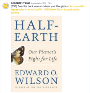
How much of the Earth should be protected from the plunder and hapless trampling of humanity? This is the central question animating E.O. Wilson’s new book Half-Earth: Our Planet’s Fight for Life. As the father of the term “biodiversity” and an early thought leader in the world sustainability, Wilson has long provided society a vast reservoir of concepts and insights that any person thinking about, or working on, sustainability should master. This is why we must all take his most recent thesis seriously.

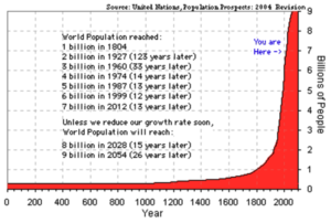
Wilson’s biodiversity lens leads him to focus our attention on the major species collapse that has been underway, and accelerating, over the past couple/few centuries, as humanity has experienced exponential growth, explosive industrialization, and processes of urbanization and suburbanization, all of which have impinged, geographically, on critical ecosystems and the species they support.

population

In Half-Earth, Wilson shines a bright light on the need to protect entire ecosystems, as geographically contiguous spaces, since the complex relationships between all of the species within an ecosystem cannot be thought of as severable. In his estimation, if we are to prevent the impending complete planetary species collapse, which would have cataclysmic implications for carrying capacity of the Earth as humanity’s ecosystem, at least half of the Earth’s surface needs to be protected from the human footprint.
Through the course of his book, Wilson talks about some specific places that he believes should be protected from humanity, but mostly refers to existing protected areas, which of course each have concrete geographical representations, which can be viewed and analyzed in a Geographic Information System (GIS). However, beyond these protected areas, Wilson largely does not tell us what other geographies must be protected in order to get us to half of the Earth’s 509.97 million km2 (let’s just round down to 250 million km2).

“Today every sovereign nation in the world has a protected-area system of some kind. All together the reserves number about a hundred sixty-one thousand on land and and sixty-five hundred over marine waters. According to the World Database on Protected Areas, a joint project of the United Nations Environmental Program and the International Union for Conservation of Nature, they occupied by 2015 a little less than 15 percent of Earth’s land area and 2.8 percent of Earth’s ocean area. The coverage is increasing gradually. This trend is encouraging. To have reached the existing level is a tribute to those who have led and participated in the global conservation effort. But is the level enough to not just slow but halt the acceleration of species extinction? Unfortunately, it is in fact nowhere close to enough. Might the upward trend conservation efforts have set be enough during the rest of the century to save most of Earth’s biodiversity? That is problematic, but I doubt that it can be, and even then there will be far less biodiversity to save.”

Well, there you have it. When you place the bounding geometries of all existing protected areas on a map, you are left far from the goal needed for wholesale species collapse over the coming century – at least in Wilson’s assessment. So, what other geographies comprise the remaining 35% of the Earth’s land area, and 47.2% of the Earth’s ocean area if we are to reach Wilson’s goal?

This is one of the central questions behind this year’s Fall Symposium of the American Geographical Society, entitled Geography2050: Envisioning a Sustainable Planet. Thinkers and Doers from industry, government, academe and the social sector will provide their insights as to the geographies over which various conservation, restoration and other sustainability strategies will need to be deployed if we are to meet our collective societal goals by 2050. They are all encouraged to propose their own concrete geographies that relate to their specialty, whether it be forests, oceans, the Arctic, iconic species, sustainable cities, or what have you.

But, this is a thought exercise that everyone can become a part of. For those of you on Twitter, check out the invitation to participate at https://twitter.com/geography2050.

screen-shot-2016-10-03-at-12-54-11-pm

screen-shot-2016-10-03-at-12-54-52-pm

screen-shot-2016-10-03-at-12-55-18-pm

screen-shot-2016-10-03-at-12-55-28-pm

screen-shot-2016-10-03-at-12-55-37-pm

screen-shot-2016-10-03-at-12-55-50-pm

screen-shot-2016-10-03-at-12-56-08-pm

screen-shot-2016-10-03-at-12-56-23-pm

screen-shot-2016-10-03-at-12-56-32-pm

screen-shot-2016-10-03-at-12-56-42-pm

Who knows whether it is Donald Trump or Hillary Clinton who will become our next President of the United States. Rest assured, however, that the American Geographical Society will share the results of their “expedition to the future” with the future President, informed by the geographies that all of us believe need to be protected – far beyond the protected areas that are formally institutionalized today. So, Tweet your thoughts to @geography2050 today or email them to [email protected], and perhaps you can help shape a sustainable future for our planet.

But, just in case you are just too trapped within your human-centric mindset, and are having a hard time thinking about a world less trammeled by humanity, just remember some of E.O. Wilson’s concluding words:

“Wildlands are our birthplace. Our civilizations were built from then. Our food and most of our dwellings and vehicles were derived from them. Our gods lived in their midst. Nature in the wildlands is the birthright of everyone on Earth. The millions of species that we have allowed to survive there, but continue to threaten, are our phylogenic kin…History without the wildlands is no history at all.”

And there you have it.

 

Move over Internet of Things – Here comes Space Time Robotics

robot-earth.hallmarkThe Internet of Things (IOT) is a hot topic these days.  All the cool kids are doing it.  Every company is adopting it as their battle flag.  While “The Internet of Things” (IoT) as an idea has been around since 1999, it has only come into its own in the past few years.  And, in 2014, it seems that nearly every tech writer was compelled to fan the flames of interest in the subject.  Going back to its beginning, I always liked the idea of IoT, but also found it vaguely unsatisfying.  Maybe its because I was never an EE guy focused on the physical networking layer.  I guess I always assumed the Internet’s existence, and focused on the Web layer.  After all, I left my small town for the big city in order to go to college just as the World Wide Web was emerging.  So, for me, it was all Web all the time.

At virtually the same time that IoT was coined, I met Dr. Mike Botts at a Technical Committee meeting of the Open Geospatial Consortium (www.opengeospatial.org) in Atlanta.  It was the first TC for both of us.  I was a new sponsor of the OGC, in my role as Chief Strategic Officer of In-Q-Tel, the CIA’s venture fund.  He was a principal research scientist at the University of Alabama at Huntsville, having done a stint at NASA headquarters, trying to figure out a strategy and implementation that might help achieve interoperability amongst their many sensors.  Space based sensors, predominantly.  But, Mike came in to the OGC process with a rich vision for sensor interoperability in which his “SensorML” could be used as an abstraction layer that would enable an architecture for constructing massively distributed, heterogenous SensorWebs comprised of space based, airborne, mobile, in situ and terrestrial remote sensors.  Not a network (e.g., Internet).  But a web (e.g., WWW).  Sensor Web Enablement (SWE) is the term that emerged within the OGC process.  SensorWeb was the shorthand.  And, within the OGC, all SensorWebs were rigorously geospatially-enabled and location aware.  As such, the whole time everyone was talking more and more about the Internet of Things, all I could think about the Location Enabled Web of Things.  Too bad “LEWoT” was a horrible acronym.  Otherwise, given the tech world’s fetish for snappy acronyms, regardless of the irrelevance of the content backing them up, we could have been off to the races within something well beyond what that IoT had to offer.  But, alas…

Interestingly, the OGC SWE architecture continued to evolve at a healthy pace, and it became widely adopted, on a global scale.  I like to say that it succeeded at becoming a globally adopted architecture, but not ubiquitous.  By 2009 or so, people were using SWE to task remote sensing satellites, task UAVs and their sensors, publish ocean buoy networks, enable webcams as location aware services, demonstrate terrestrial remote sensors such as doppler radars, and publish a variety of mobile and in situ sensors as interoperable OGC services.  The EU even developed a program called “Sensors Anywhere” (or SANY)  from which a book was authored.  As a member of the Board of Directors of the Open Geospatial Consortium, this evolution was a point of pride.  OGC had midwifed a global architecture that could deal with the most simple to the most exotic sensors on the planet, as well as near space.

Somewhere over this evolution, things got curiouser and curiouser.  I remember asking Mike “So, SWE isn’t just dealing with sensors?”, observing that applications of this architecture were doing things like tasking the movement of platforms like UAVs.  It was then that Mike blew my mind.  “Well, SensorML and SWE support sensors, actuators and processes.”  To a non-engineer, this is the kind of succinct statement that I remember my best professors leaving me to chew on for years.  Over many beers and many conversations (yes, I am slow), I came to ask things like “so, could you interface with a constellation of semi-autonomous robots using SWE?”  To which Mike would say things like, “Well, they are simply combinations of sensors, actuators and processes.  So, yes!”.  A constellation of geographically-enabled, location aware, semi-autonomous robots orchestrated and managed by SensorML and SWE.  Now that would be crazy.

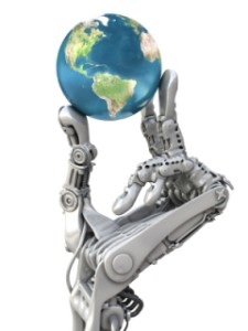
This was the moment when I became unsatisfied not only with the term IoT, but also with Sensor Web Enablement, or SensorWebs.  They are perfectly good terms, so don’t get me wrong.  In particularly, I would definitely self-identify as a “sensor freak”.  And, I am super thrilled with the latest evolution of Mike’s OGC SWE vision, with the launch of his team’s license free open source software platform for geospatial (FOSS4G) sensors, called OpenSensorHub (www.opensensorhub.org).  But, both these terms fail to grasp what I consider to be the key elements of the emerging future.  What platforms like OpenSensorHub will enable is what I have taken to calling “Space Time Robotics”.  After all, what do you get when you integrate sensors, actuators and processes?  Robots.  Thats what.  And, not just anthropomorphic robots like Twiki from Buck Rogers or “Robot”(full name, B-9, Class M-3 General Utility Non-Theorizing Environmental Control Robot) from Lost in Space (did I just date myself?).  Robots will manifest in a variety of forms, including massively distributed networks of sensors, actuators and processes that shape how we experience the landscape in which we live.  And, when they are geographically-enabled and location aware…or more specifically, spatio-temporally aware…what will happen?  Their existence, observations, assessments and actions will span time and space.  The same time and space in which we as human will exist.  So, sure.  The Internet of Things is great.  But, the era of Space Time Robotics will arrive sooner than we imagine, and the term IoT will feel insufficiently descriptive when it does.

Water Skiing in Dubai

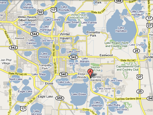
Cypress Gardens Theme Park Map
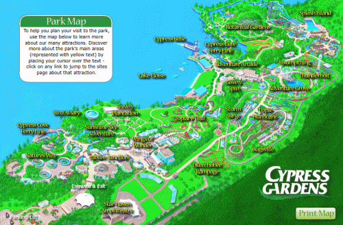
This evening, I was browsing my hometown paper, the Winter Haven News Chief and found an great little article about the waterskiers at Cypress Gardens being hired to perform all over the world.  When Cypress Gardens changed ownership (long story) and became less of a classic Florida naturalist park (like Weeki WacheeSunken GardensGatorLandBok Tower Gardens, etc.) and more of a theme park, cost cutting led to the outsourcing of waterski show team.  It used to be that all the best skiers at my high school worked at Cypress Gardens (my friend Ryan was Corky the (Waterskiing) Clown for a while).  Lets just say that we had plenty of lakes to ski on in my home town.  I grew up on Lake Howard, but skied on every single lake in the “Chain O’ Lakes”, and some that weren’t on the Chain.  If you zoom out on GoogleMaps, you will see the ridiculous density of lakes in the region.

Winter Haven FL

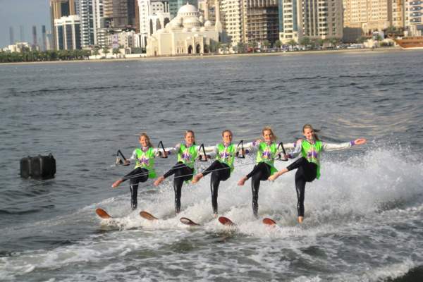
Some 20 lakes were/are chained together since the 1920s (this would not be approved by the EPA these days!), and we would hop in a ski boat and pick a lake to go skiing in.  If you wanted some entertainment while you were eating lunch in your boat, you could just pull right up to the rope and bouys at Cypress Gardens on Lake Eloise, and watch the ski show.  And, this is the sort of thing that you would see (minus the mosque in the background!)
Cypress Gardens Skiers in Dubai

Photo courtesy of Stars of Florida

I wish I had pictures for you of Corky the Clown doing a back flip.  I don’t know, but I think this sort of thing is some of the best diplomacy America could be doing around the world.  Who’s replacing James Glassman at the Department of State?  If you know his replacement, do me a favor and send him the link to this blogpost!