I know it isn’t released, but if this guy isn’t completely daffy, then I will have to completely rework all of my assumptions about how to tackle global warming, alternative energy generation, and reducing dependence on foreign oil. After listening to Saul Griffith calculate (or recalculate…) the globe’s energy requirements and the alternative energy requirements that must be met in order to avoid certain cataclysmic carbon thresholds, I figured that we were beyond the point of no return. All of his calculations involved building or deploying so many or so much so fast, starting yesterday, that I saw no way to hit the mark before 2050.
Then comes this guy, “The Father of Deep Natural Gas”, in this Aspen Strategy Group forum. I tell you what, his diagnosis of the situation, his estimate of the amount of Deep Natural Gas available in North America (and worldwide for that matter), his commentary on the politics of oil and why Official Washington has ignored natural gas, makes me very concerned that the Obama Administration is jumping to a cap and trade system before looking at this. Especially given his commentary on what cap and trade would and would not be capable of solving. And, given what he sees being achieved in merely 5 years, if the right resources were applied (e.g., STIMULUS PACKAGE!!!!), I think someone at the White House should be paying attention.
But, then again, perhaps this guy is a nut job. However, I simply suspect that Hefner is right, and it is one of those things that Official Washington ignores because it is inconvenient. Of course, “An Inconvenient Truth” has recently been deemed not-so-inconvenient. So, I guess we are at an impasse. If “An Inconvenient Truth” is not too inconvenient, then why should this be?
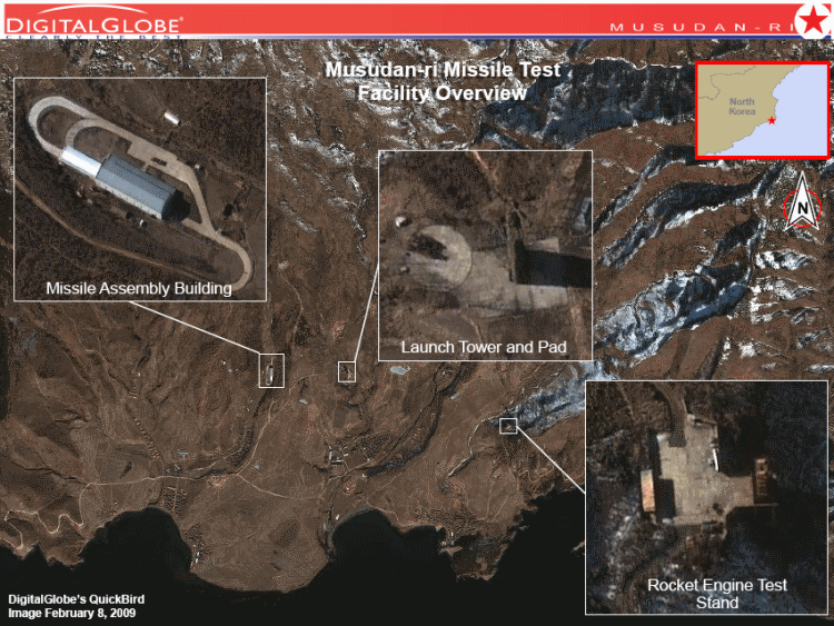
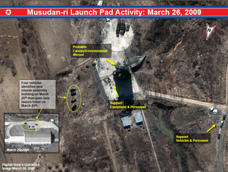
So, according to Jeff’s reconnaissance package, “The Musudan-ri missile assembly building is (according to globalsecurity.org) capable of handling two Taepodong-2 class three stage launch vehicles, in addition to several vertical test cells in the high bay portion.” Then, Wikipedia says:
Striking Anchorage in Alaska (one of the closest potential mainland US targets) could be difficult given that the distance from the launch site co-ordinates (see below) and Anchorage is 5,634 km[3]. However the range specified below details 4,500 km, meaning the missile would fall short by around 1,000km. It is only future variants (i.e. planned missile designs that are still on the drawing board), that could reach up to 9,000km therefore it is misleading to suggest that the Taepodong 2 that is due to be test-fired between April 4th and 8th 2009 has the ability to reach mainland US targets. Based on the size of the missile, the fuel composition, and the likely fuel capacity, it is estimated that a two stage variant would have a range of around 4,000 km (2,500 statute miles) and a three stage variant would be capable of reaching as far as 4,500 km (2,800 statute miles), giving it potentially the longest range in the North Korean missile arsenal.[1] The burn time of each stage is a little over 100 seconds, thus allowing the missile to burn for 5 or 6 minutes. Future highly speculative variants of the missile could be capable of a range of approximately 9,000 km (5,600 statute miles).[4] At maximum range, the Taepodong-2 is estimated to have a payload capacity of less than 500 kg.[2] Whether this would be large enough to carry a North Korean designednuclear warhead is currently unknown, as the full development status of the North Korean nuclear program is largely unknown. Early versions did not have the payload or range to launch a satellite into space.
No problem for Governor Palin, but I guess Japan has got to be unhappy. I would love to be a fly on the wall at the next round of the Six-Party Talks. Perhaps they are just pissed that we took Christopher Hill away from them!
More from the reconnaissance package,
“An imagery review of the launch complex from previous DigitalGlobe imagery during late June, 2006 revealed similar activity at the launch pad and missile assembly building prior to the July 5, 2006 Paektusan/TaepoDong-2 missile launch.
According to Janes Defence Weekly, in 2006 the Paektusan-2 sat on the launch pad (within the launch tower) for approximately 20 days before being launched.”
Hopefully Stratfor will consider this advertising, or at least falling under Fair Use! Since I consider this blog my personal file system for things I don’t won’t to lose track of, I am including a healthy extract from this Stratfor article as its the best explanation of the challenge from a geostrategic perspective. It would have been nice to have dealt with Afghanistan consistently since 2001.
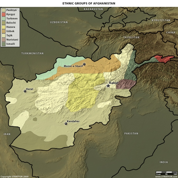
Landlocked by Iran, Central Asia and Pakistan, Afghanistan is destined to be poor and insulated. As a largely arid, resource-deficient no-man’s-land, the country lacks strategic value in and of itself and historically has served as a thoroughfare for invaders descending from the Central Asian steppes in search of the Indian subcontinent. Afghanistan stands out among the world’s countries in that it has no core region that defines itself as the Indus River Valley does for Pakistan or as the Zagros Mountains do for Iran. The region’s central mountain knot keeps most of its various ethnicities perched on the edges of the knot where water is available, but there are no meaningful barriers that separate them from each other. The result is a hodgepodge of ethnic groups and tribes constantly competing for dominance, endlessly able to dislodge their neighbors and yet lacking the natural barriers that could give them real security in the long run. Any outsider, therefore, will find Afghanistan easy to conquer — as did the Russians in 1979 and the Americans in 2001 — but impossible to hold. Representing a battered mix of ethnicities, the Afghan people have been hardened by wars of their own making and those brought to them by outsiders. Territory changes hands often, and the people pledge their loyalties accordingly.
Afghanistan’s geographic features essentially deny the United States a successful military strategy. When the United States fights wars in Eurasia, it already expects to deal with critical disadvantages, such as having its forces far outnumbered and having to maintain long and vulnerable supply lines. From almost its very beginning, the United States has conducted expeditionary military operations overseas; since World War II, it has come to rely on its global maritime dominance and technological edge to impose its influence far beyond U.S. coastlines. In the present case of Afghanistan, however, all the strengths that the United States typically brings to a military operation are more or less nullified. With no real power base, the United States is fighting a stateless entity in a landlocked country with a scattered population. Such a dynamic prevents the United States from utilizing its naval prowess and complicates the use of advanced weapons systems, particularly when use d against a guerrilla enemy dispersed throughout the countryside. The only way to fight in Afghanistan is to use brute force and significant numbers of boots on the ground in a war of occupation — precisely the sort of war that lies outside the U.S. comfort zone.
In other words, Afghanistan’s geography in many ways denies the United States any good policy options. Afghanistan historically has been a country exceedingly difficult for an outside power to pacify. At the very best, the United States can hope for a loose and shifting confederation of Afghan tribes and ethnic groups to try and govern the country and prevent transnational jihadist forces from taking root again. But for that strategy to work, the United States would first need to devote an immense amount of time and resources to long-term counterinsurgency and nation-building in a region extremely resistant to the sort of stability required for nation-building. Without the 9/11 connection, Afghanistan would continue to sit very low on the totem pole of U.S. strategic interests.
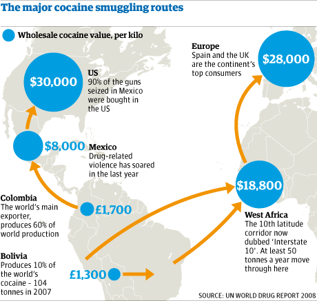
This (geo)graphic comes from an article in today’s Guardian UK.
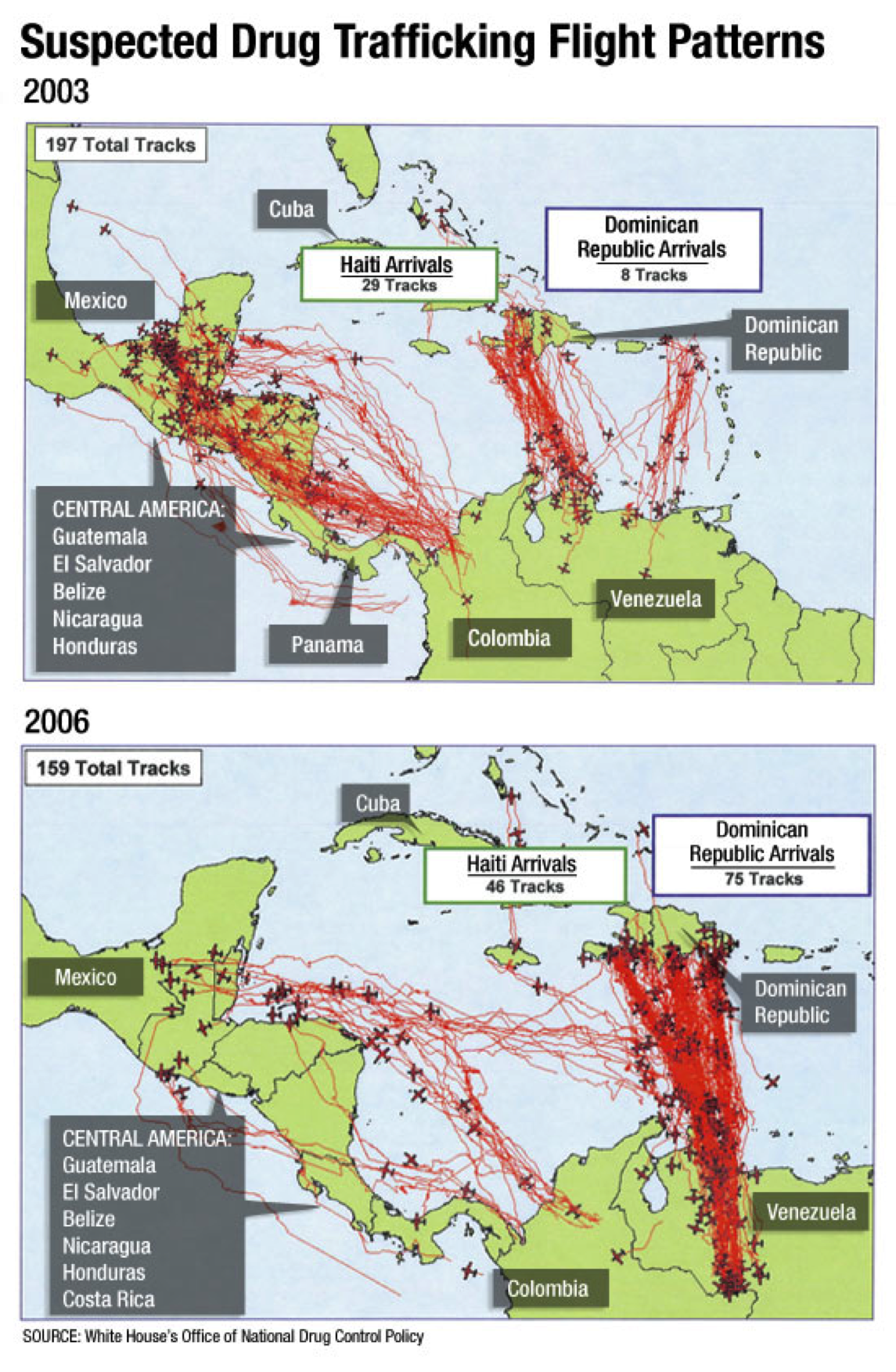
I had not heard of the 10th latitude corridor (e.g., Interstate 10), but I guess there had to be a name for it. Interestingly, this map does not flush with this one from the White House Office of Drug Control Policy.
I was having a conversation with Amjad Atallah of the New America Foundation about the power of maps in defining lines of peace and conflict in the realm of foreign affairs. He had a couple great stories relating to the Israeli/Palestinian conflict.
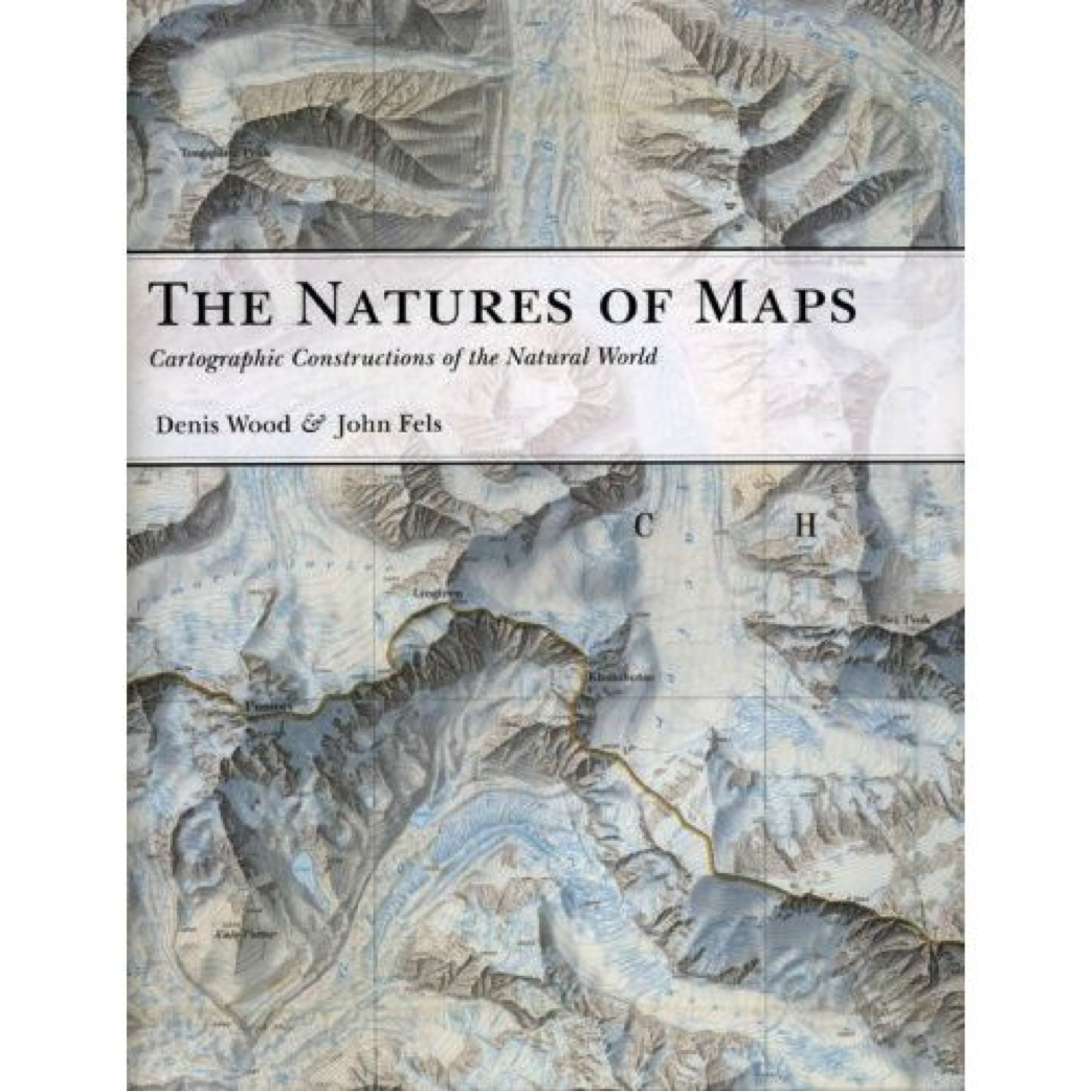
At the time, I was specifically thinking about the power of planning documents such as RAND’s Arc proposal in shaping the negotiations over political and institutional issues, as such documents provide a clear vision of what might be possible if the parties come to agree on particular political/institutional terms. But, I struggled for some useful language. Recently I received a book review, published in Nature byJon Christensen, of Wood and Fels’ “The Nature of Maps” which had this great quote:
Maps are indeed arguments about our world, but the future also rides on maps. People use them to shape what we know and what becomes of the territory. As Wood and Fels argue so provocatively, “Pretending to be no more than scorekeepers, maps stand revealed as more like the ball, the very medium through which the game’s moves are made.”